Conference Venue
 |
With a population of 280,000, Leicester is the largest city in the East Midlands and the tenth largest in the country.
Its importance was first recognised by the Romans and later by the Danes, who used it as a strategic stronghold to control the Midlands. Since then it has developed into a major commercial and manufacturing centre, known better for the diversity of its trade than for its dependence on a single industry.
It is also a historic meeting place. For centuries people of different races and cultures have gathered in Leicester, creating a rich and unique heritage. This diversity continues today. The city's thriving ethnic minority community accounts for more than a third of Leicester's population and continues to enrich city life.
|
Although it was referred to in the Domesday Book as a ‘civitas’ –
or city – it lost that status during the 11th century, when power
struggles between the Church and the aristocracy led to
Leicester’s civic demise.
For the next 800 years, Leicester – one of the most important
places in Britain in terms of wealth, trade and religion – was
known as a borough or town.
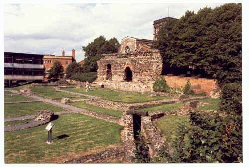
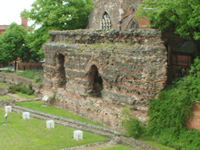
Ratae Coritanorum, later to become Leicester, was originally an
important Roman military centre at the junction of the Fosse Way
and the road from Colchester to the centre of the country. When
the military frontier was pushed further to the north and west,
Leicester became a civilian town with the standard grid iron
street layout.
The best remains are of the bath house and its high back wall. The
depth of the foundations below present street level shows how
accumulations over the 1,500 years since Roman times have raised
the height of the land.I |
 |
There is a strong likelihood of continued occupation after the
Romans withdrew to the south, though perhaps at a reduced
population level.
A little later, Leicester was an important town in the Danish
period, with its own mint. There is also firm evidence of a
flourishing town at the time of the Norman Conquest in 1066 and
the Domesday Book of 1086, with a recorded population of 2,000.
|
 |
In
Medieval times there was some re-aligning of the street layout
from the Roman grid iron pattern but this would not have been
deliberate.
Outside the city walls the Fosse Way ran almost straight to
Lincoln from the East Gate and south-westwards towards High Cross
from the West Gate. The New Walk shows the line from the South
Gate. The road to the north was somewhat less distinct, running
close to and across the marshes through which flowed the sluggish
River Soar.
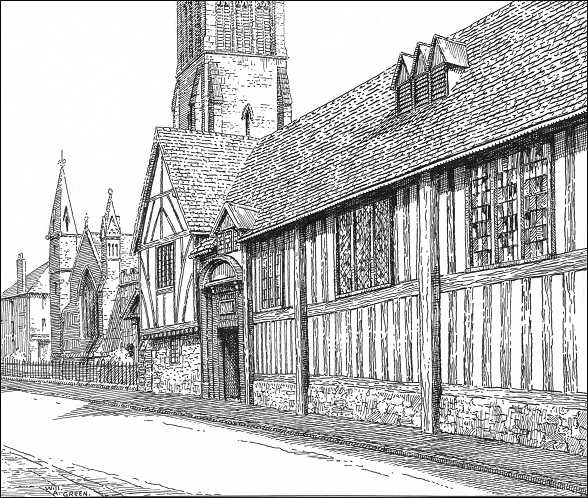
The town was still small and confined within the medieval walls,
with the Castle, the Newarke, Blackfriars and White Friars as
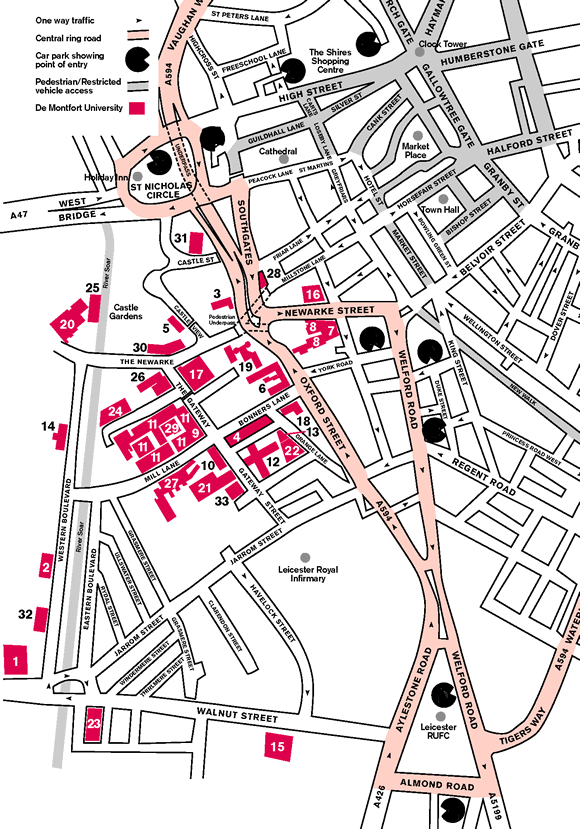
extra-parochial areas outside the jurisdiction of the town (see
map). |
The medieval Gild of Corpus Christi founded in 1343, which met in
the
Guildhall, had close links with the Church. The Gild had its
location close to St Martin's and was the forerunner to the city
council of today. The merchants ran the industrial and commercial
life of the town and were, in effect, its unelected rulers.
The Church was also strong during the period. Leicester Abbey was
a major monastic foundation to the north of St Margaret's Parish
and owned extensive areas of land. All the villages that are now
part of Leicester's suburbs - Belgrave, Evington, Knighton,
Aylestone, Braunstone and the open areas of New Parks and Beaumont
Leys - were completely separate at this time.
Transport links were always poor, with the main roads passing to
the east (the A1), the south and west (A5) and the A6 to the north
down the Soar Valley being subject to winter flooding.
Neither was the River Soar navigable, as it was too small and
shallow. This made the import and export of goods very difficult,
though this was partially solved by the construction of the Soar
Navigation in the 1790s, first to Loughborough and then to
Leicester. Gradually it was extended southwards to join up with
the Grand Union Canal.
The 1832 Swannington to Leicester Railway enabled coal to be
brought into the city at low cost and the Midland Counties Railway
with its original station in Campbell Street followed in the
1840s.
The spread of steam power enabled factories to be established,
especially along the riverside. The city became one with a large
number of chimneys, the factories being concerned with engineering
and the manufacture of boots and shoes and of hosiery and
knitwear. Suburbs constructed for workers were rapidly built as
speculative developments, especially in Belgrave, Highfields and
the West End, with more substantial developments for the wealthy
out along the main roads, especially the London Road in Stoneygate
and Clarendon Park.
|
 |
After much lobbying, city status was finally restored by King
George V at the end of the First World War.
After the First World War the city expanded with the construction
of new housing estates, partly to replace unfit housing in the
inner areas of the city and partly to house those who were moving
in from the countryside. Large areas of land were taken into the
area of the city and covered with housing on an extensive scale,
including the Saffron and Braunstone Estates.
 |
Also at this time industrial estates were first created,
separating industry from the residential areas. Evington Valley
was the first.
Since World War Two, a major development has been the growth of
private car ownership and the problems that congestion has brought
to the city.
Pressure on space has caused major redevelopment requirements and
large areas of the city centre have been demolished and rebuilt.
The suburbs have being relatively untouched, apart from the
construction of the Outer Ring Road.
|
|
Pressures of population have also required major new residential
growth in New Parks, Rushey Mead, Eyres Monsell, Evington, Thurnby
Lodge, Netherhall, Beaumont Leys and Hamilton, as well as in areas
outside the city boundary.
There has been major social change within the population structure
of the city since the War. Citizens immigrating form other
countries, including India, Pakistan, Bangladesh and the
Caribbean, now form a large percentage of the city's population.
These residents are making a major contribution to the industrial
and commercial life of the city, especially via the creation of a
myriad of small family businesses and participation in the
professional life of the city.
|
 |
Conference
Site
 |
|
 |
De Montfort University is a dynamic organisation,
formed from a diverse range of specialist institutions.
Its long history of excellent teaching, learning and
research is founded in the technical and trade education
of the late 19th Century. The name itself is associated
with Simon De Montfort, Earl of Leicester, a
distinguished figure in English history and widely
credited with establishing the first parliament in 1265.
Prior to 1992, De Montfort University was known as
Leicester Polytechnic which was created in 1969 through
the amalgamation of Leicester College of Technology and
Leicester College of Art. The polytechnic was
established as a corporation in 1989.
In 1992, following the official
opening of the Milton Keynes campus by HM the Queen, De
Montfort University was born. Mergers took place with
Bedford College of Higher Education, Lincolnshire College of
Art and Design and Lincolnshire College of Agriculture and
Horticulture in 1994. In 1995, the University merged with
Charles Frears College of Nursing and Midwifery. Since then
extensive international links have led to collaborative
partnerships across the globe.
Today, the university has 4 campuses
at 2 centres, and special arrangements with more than 60
universities and colleges in 40 countries. It has
approximately 23,000 students, 3,300 staff, and an annual
turnover in the region of £106 million.
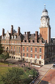
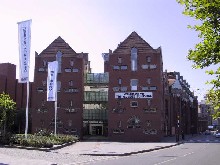
The conference itself
will be held at the
LEC QB Queens Building
Address Mill Lane, Leicester, Leicestershire, LE2 7DR (building 27
on the map) Room numbers: 1.25 ....
|
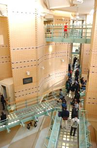
You can have a virtual tour inside
the building on this link:
http://www.dmu.ac.uk/aboutdmu/campuses/vt/unidemrjm.jsp#
|
 |
How to reach Leicester and the
Conference Site |
 |
 By Air
 |
Airports
East Midlands (now called
Nottingham East Midlands Airport)

The nearest public airport to Leicester
is
East
Midlands. Its web site has information about the nearest
hotels and where to park.
There is no direct rail link from the
airport to Leicester. It would be necessary to travel to
either Nottingham, Derby or Loughborough to catch a train.
There are direct bus services from East
Midlands to the surrounding cities. The Airport is very
close to the M1 Motorway.
East Midlands International Airport
Castle Donington
Derbyshire
DE74 2SA
Phone: 01332 852852 International: +44 (0)1332 852 852 Fax: 01332 850393
There is another web site with
information on
East Midlands Airport This site gives information on how
to get to the airport by rail, bus and road.
Hotels in the vicinity of the
airport include
the Donnington Thistle Hotel
East Midlands Airport
Castle Donnington
Derby
DE74 2SH
Phone: 0332 850 700
Other airports serving Leicester
Birmingham:
Birmingham International Airport
The Airport has a train station at
Birmingham International.
Luton
There are direct train services from
Luton to Leicester
Further afield
London
(Heathrow)
Gatwick Airport
Manchester Airport
There is a frequent train service
between the Airport and Manchester Piccadilly
Flights
British
Midland Fly bmi | Sales center 0870 60 70 555 (UK only)
+44 1332 854854 (Outside of UK)
bmi fly from East Midlands airport to
Amsterdam, Belfast, Brussels, Dublin, Edinburgh, Faro,
Frankfurt, Glasgow, Guernsey, Jersey, Malaga, Nice, Palma
Mallorca, and Paris.
Bus connections
There are bus (coach) connections
between Leicester and Luton, Heathrow and Gatwick. The
operator is National Express . For further
information or bookings see
National Express
More information
Travelling from overseas to the UK? See
our
links page for information
 By Train
 |
Leicester
station
 The principle railway terminus is
Leicester London Road station. This is located very near to
the centre of the City with some large and smaller hotels
within either walking distance or a short taxi ride. The principle railway terminus is
Leicester London Road station. This is located very near to
the centre of the City with some large and smaller hotels
within either walking distance or a short taxi ride.
Taxis
The station has a busy forecourt with
taxis being available at all times.
Connections are available from Leicester
across country in the direction of Birmingham or
Peterborough.
Trains running between London and
Nottingham usually stop at Leicester; trains from Leicester
to Nottingham run every 30 minutes at peak times.
Connections can also be made to
small towns in the County incuding Hinckley, Narborough,
Wigston, Melton Mowbray and Oakham in Rutland.
Location
Click here for an on-line map showing the location of
London Road station.
On this map the station is shown with a
red circle on a black and white line.
Leicester is connected to main line rail
networks with frequent services to London, Birmingham,
Nottingham and many other places. The station is a 10 minute
walk from the city centre.
Timetables
Rail web sites
 By Road
 |
By Car
Leicester has the M1 (junction 21) and the M69 motorways
intersecting just outside the city.
By Bus and Coach
A number of coach companies travel to and from Leicester
from most major cities.
Inter city coaches and local buses
arrive at two termini for local bus services:
St Margaret's Bus Station in Gravel
Street which is fairly close to the centre of the city (see
the Street Map link below)., and the Haymarket Bus Terminus
in Charles Street (at the Haymarket Shopping Centre.)
Click here for the location of St Margaret's bus and
coach station in Gravel Street.
National coach services
Inter city coaches
and local buses arrive at St Margaret's bus station which is
fairly close to the centre of the city.
For details of routes and journeys use
the
National Express web site or call 08750 80 80 80 (uk
only).
Timetable for
Trent and Barton buses which provides routes in
Nottinghamshire, Derbyshire and other areas.
Local
bus services
UK Public
Transport Information - Covering all travel by rail,
air, coach, bus, ferry, metro and tram within the UK,
(including the Channel Islands, Isle of Man and Northern
Ireland) and between the UK and Ireland. Plus all rail,
ferry and coach travel between the UK and mainland Europe.
ARRIVA
Fox County
852 Melton Road
Thurmaston
Leicester
LE4 8BT
For timetable information phone
Traveline (below).
Tel: 0116 253 9534 or 0116 264 0400
Fax: 0116 260 5605
ARRIVA Fox County operates an extensive
network of bus services throughout Leicestershire. Information about
Regional Bus and Coach services
- Telephone Traveline on: 0870 608 2608. 7am to 9 pm, seven days a week.
- A local bus service locator is available at
www.leicesterequal.co.uk.
- Click here for
Arriva's website, providing the latest bus timetables,
route maps and other information.
- Click here for
First Leicester's website, providing information on
maps, routes. timetables, fares and tickets.
- For details of buses in Leicester
City, see the
bus
page
- Need to phone - try
Travel Line - public transport information
Car Rental
 Avis Rentals
Other Information
The Leicester Survival Guide
The De Montfort University has put
together a survival guide for Leicester in pdf format. You
can download it
here.

|
|
 |