Venue
|
Valletta
Il-Belt Valletta
|
|||||||||||||||
|---|---|---|---|---|---|---|---|---|---|---|---|---|---|---|---|

From top: Skyline, Saluting Battery, Lower Barrakka Gardens, St. John's Co-Cathedral and the city walls
|
|||||||||||||||

Flag

Coat of arms
|
|||||||||||||||
|
Nickname(s):
Il-Belt
|
|||||||||||||||
|
Motto(s):
City Built By Gentlemen For Gentlemen
|
|||||||||||||||

Map of the Maltese Archipelago with Valletta highlighted in red.
|
|||||||||||||||
| Coordinates: 35°53′54″N 14°30′45″E / 35.89833°N 14.51250°ECoordinates: 35°53′54″N 14°30′45″E / 35.89833°N 14.51250°E | |||||||||||||||
| Country | Malta | ||||||||||||||
| Region | South Eastern Region | ||||||||||||||
| District | South Harbour District | ||||||||||||||
| Established | 28 March 1566 | ||||||||||||||
| Capital city | 18 March 1571 | ||||||||||||||
| Founded by | Jean de Parisot Valette | ||||||||||||||
| Borders | Floriana | ||||||||||||||
| Government | |||||||||||||||
| • Mayor | Alfred Zammit (PL) | ||||||||||||||
| Area | |||||||||||||||
| • Capital city and local council | 0.61 km2 (0.24 sq mi) | ||||||||||||||
| Elevation | 56 m (184 ft) | ||||||||||||||
|
Population
(Jan. 2019)
|
|||||||||||||||
| • Capital city and local council | 5,827 | ||||||||||||||
| • Density | 9,600/km2 (25,000/sq mi) | ||||||||||||||
| • Urban | 355,000 | ||||||||||||||
| • Metro | 393,938 | ||||||||||||||
| Highest Record Population (1875): 25,275 | |||||||||||||||
| Demonym(s) | Belti (m), Beltija (f), Beltin (pl) or Vallettan (m), Vallettana (f), Vallettani (pl) | ||||||||||||||
| Time zone | UTC+1 (CET) | ||||||||||||||
| • Summer (DST) | UTC+2 (CEST) | ||||||||||||||
| Postal code |
VLT
|
||||||||||||||
| Dialing code | 356 | ||||||||||||||
| ISO 3166 code | MT-60 | ||||||||||||||
| Patron saints | St. Dominic Our Lady of Mount Carmel St. Paul St. Augustine |
||||||||||||||
| Day of festa | 3 August 10 February |
||||||||||||||
| Website | Official website | ||||||||||||||
|
|||||||||||||||
Valletta (/vəˈlɛtə/, Maltese: il-Belt Valletta, Maltese pronunciation: [vɐˈlːɛtːɐ]) is the capital city of Malta. Located in the South Eastern Region of the main island, between Marsamxett Harbour to the west and the Grand Harbour to the east, its population in 2014 was 6,444, while the metropolitan area around it has a population of 393,938. Valletta is second only to Nicosia as the southernmost capital of Europe, and at just 0.61 square kilometres (61 ha), it is the European Union's smallest capital city.
Valletta's 16th-century buildings were constructed by the Knights Hospitaller. The city was named after Jean Parisot de Valette, who succeeded in defending the island from an Ottoman invasion during the Great Siege of Malta. The city is Baroque in character, with elements of Mannerist, Neo-Classical and Modern architecture, though the Second World War left major scars on the city, particularly the destruction of the Royal Opera House. The city was officially recognised as a World Heritage Site by UNESCO in 1980.
The city's fortifications, consisting of bastions, curtains and cavaliers, along with the beauty of its Baroque palaces, gardens and churches, led the ruling houses of Europe to give the city its nickname Superbissima – Latin for "Proudest".
History

The peninsula was previously called Xagħret Mewwija (Mu' awiya – Meuia; named during the Arab period) or Ħal Newwija. Mewwija refers to a sheltered place. The extreme end of the peninsula was known as Xebb ir-Ras (Sheb point), of which name origins from the lighthouse on site. A family which surely owned land became known as Sceberras, now a Maltese surname as Sciberras. At one point the entire peninsula became known as Sceberras. (See also)
Order of Saint John

The building of a city on the Sciberras Peninsula had been proposed by the Order of Saint John as early as 1524. Back then, the only building on the peninsula was a small watchtower dedicated to Erasmus of Formia (Saint Elmo), which had been built in 1488.
In 1552, the Aragonite watchtower was demolished and the larger Fort Saint Elmo was built in its place.
In the Great Siege of 1565, Fort Saint Elmo fell to the Ottomans, but the Order eventually won the siege with the help of Sicilian reinforcements. The victorious Grand Master, Jean de Valette, immediately set out to build a new fortified city on the Sciberras Peninsula to fortify the Order's position in Malta and bind the Knights to the island. The city took his name and was called La Valletta.
The Grand Master asked the European kings and princes for help, and he received a lot of assistance, due to the increased fame of the Order after their victory in the Great Siege. Pope Pius V sent his military architect, Francesco Laparelli, to design the new city, while Philip II of Spain sent substantial monetary aid. The foundation stone of the city was laid by Grand Master de Valette on 28 March 1566. He placed the first stone in what later became Our Lady of Victories Church.

In his book Dell’Istoria della Sacra Religione et Illustrissima Militia di San Giovanni Gierosolimitano (English: The History of the Sacred Religion and Illustrious Militia of St John of Jerusalem), written between 1594 and 1602, Giacomo Bosio writes that when the cornerstone of Valletta was placed, a group of Maltese elders said: "Iegi zimen en fel wardia col sceber raba iesue uquie" (Which in modern Maltese reads, "Jiġi żmien li fil-Wardija [l-Għolja Sciberras] kull xiber raba' jiswa uqija", and in English, "There will come a time when every piece of land on Sciberras Hill will be worth its weight in gold").
De Valette died from a stroke on 21 August 1568 at age 74 and never saw the completion of his city. Originally interred in the church of Our Lady of the Victories, his remains now rest in St. John's Co-Cathedral among the tombs of other Grand Masters of the Knights of Malta.
Francesco Laparelli was the city's principal designer and his plan departed from medieval Maltese architecture, which exhibited irregular winding streets and alleys. He designed the new city on a rectangular grid plan, and without any collacchio (an area restricted for important buildings). The streets were designed to be wide and straight, beginning centrally from the City Gate and ending at Fort Saint Elmo (which was rebuilt) overlooking the Mediterranean; certain bastions were built 47 metres (154 ft) tall. His assistant was the Maltese architect Girolamo Cassar, who later oversaw the construction of the city himself after Laparelli's death in 1570.
The Ufficio delle Case regulated the building of the city as a planning authority.

The city of Valletta was mostly complete by the early 1570s, and it became the capital on 18 March 1571 when Grand Master Pierre de Monte moved from his seat at Fort St Angelo in Birgu to the Grandmaster's Palace in Valletta.
Seven Auberges were built for the Order's Langues, and these were complete by the 1580s. An eighth Auberge, Auberge de Bavière, was later added in the 18th century.
In Antoine de Paule's reign, it was decided to build more fortifications to protect Valletta, and these were named the Floriana Lines after the architect who designed them, Pietro Paolo Floriani of Macerata. During António Manoel de Vilhena's reign, a town began to form between the walls of Valletta and the Floriana Lines, and this evolved from a suburb of Valletta to Floriana, a town in its own right.

In 1634, a gunpowder factory explosion killed 22 people in Valletta. In 1749, Muslim slaves plotted to kill Grandmaster Pinto and take over Valletta, but the revolt was suppressed before it even started due to their plans leaking out to the Order. Later on in his reign, Pinto embellished the city with Baroque architecture, and many important buildings such as Auberge de Castille were remodeled or completely rebuilt in the new architectural style.
In 1775, during the reign of Ximenes, an unsuccessful revolt known as the Rising of the Priests occurred in which Fort Saint Elmo and Saint James Cavalier were captured by rebels, but the revolt was eventually suppressed.

French occupation and British rule
.jpg)
In 1798, the French invaded the island and expelled the Order. After the Maltese rebelled, French troops continued to occupy Valletta and the surrounding harbor area, until they capitulated to the British in September 1800. In the early 19th century, the British Civil Commissioner, Henry Pigot, agreed to demolish the majority of the city's fortifications. The demolition was again proposed in the 1870s and 1880s, but it was never carried out and the fortifications have survived largely intact.
Eventually building projects in Valletta resumed under British rule. These projects included widening gates, demolishing and rebuilding structures, widening newer houses over the years, and installing civic projects. The Malta Railway, which linked Valletta to Mdina, was officially opened in 1883. It was closed down in 1931 after buses became a popular means of transport.
In 1939, Valletta was abandoned as the headquarters of the Royal Navy Mediterranean Fleet due to its proximity to Italy and the city became a flash point during the subsequent two-year long Siege of Malta. German and Italian air raids throughout the Second World War caused much destruction in Valletta and the rest of the harbor area. The Royal Opera House, constructed at the city entrance in the 19th century, was one of the buildings lost to the raids.
-
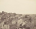
Valletta harbour around 1850, photo by Calvert Jones
-

1853 King's Gate
-

Royal Opera House in 1911
-
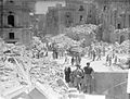
Bomb damage in Valletta during the Second World War
.jpg)
.jpg)


Contemporary
In 1980, the 24th Chess Olympiad took place in Valletta.
The entire city of Valletta has been a UNESCO World Heritage Site since 1980, along with Megalithic Temples of Malta and the Hypogeum of Ħal-Saflieni. On 11 November 2015 Valletta hosted the Valletta Summit on Migration in which European and African leaders discussed the European migrant crisis. After that, on 27 November 2015 the city also hosted part of the Commonwealth Heads of Government Meeting 2015.
Valletta was the European Capital of Culture in 2018.
-

Renzo Piano's Valletta City Gate (2014)
-

Mediterranean Conference Centre, former Sacra Infermeria (2016)
-

Renovated Tritons’ Fountain (2018)
-

Auberge d'Italie, renovated in 2016 to host the new MUŻA (Mużew Nazzjonali tal-Arti)
-

Renovated covered market Is-Suq tal-Belt, 2018


Climate
Valletta features a hot-summer Mediterranean climate with hot, slightly long, dry summers and mild, wet winters, with an average temperature above 19 °C (66 °F). Valletta experiences a lack of precipitation during the summer months and most of the precipitation happens during the winter months. Winter temperatures are moderated by the surrounding sea, as a result, the city has very mild winters. The official climate recording station in Malta is at Luqa Airport, which is a few miles inland from Valletta. Average high temperatures range from around 16 °C (61 °F) in January to about 32 °C (90 °F) in August, while average low temperatures range from around 10 °C (50 °F) in January to 23 °C (73 °F) in August.
| Climate data for Luqa Airport, Malta 1981–2010 (Records 1947–present) | |||||||||||||
|---|---|---|---|---|---|---|---|---|---|---|---|---|---|
| Month | Jan | Feb | Mar | Apr | May | Jun | Jul | Aug | Sep | Oct | Nov | Dec | Year |
| Record high °C (°F) | 22.2 (72.0) |
26.7 (80.1) |
33.5 (92.3) |
30.7 (87.3) |
35.3 (95.5) |
40.1 (104.2) |
42.7 (108.9) |
43.8 (110.8) |
37.4 (99.3) |
34.5 (94.1) |
28.2 (82.8) |
24.3 (75.7) |
43.8 (110.8) |
| Average high °C (°F) | 15.6 (60.1) |
15.6 (60.1) |
17.3 (63.1) |
19.8 (67.6) |
24.1 (75.4) |
28.6 (83.5) |
31.5 (88.7) |
31.8 (89.2) |
28.5 (83.3) |
25.0 (77.0) |
20.7 (69.3) |
17.1 (62.8) |
23.0 (73.4) |
| Daily mean °C (°F) | 12.8 (55.0) |
12.5 (54.5) |
13.9 (57.0) |
16.1 (61.0) |
19.8 (67.6) |
23.9 (75.0) |
26.6 (79.9) |
27.2 (81.0) |
24.7 (76.5) |
21.5 (70.7) |
17.7 (63.9) |
14.4 (57.9) |
19.3 (66.7) |
| Average low °C (°F) | 9.9 (49.8) |
9.4 (48.9) |
10.6 (51.1) |
12.4 (54.3) |
15.5 (59.9) |
19.1 (66.4) |
21.7 (71.1) |
22.6 (72.7) |
20.8 (69.4) |
18.1 (64.6) |
14.6 (58.3) |
11.6 (52.9) |
15.5 (59.9) |
| Record low °C (°F) | 1.4 (34.5) |
1.7 (35.1) |
2.2 (36.0) |
4.4 (39.9) |
8.0 (46.4) |
12.6 (54.7) |
15.5 (59.9) |
15.9 (60.6) |
13.2 (55.8) |
8.0 (46.4) |
5.0 (41.0) |
2.1 (35.8) |
1.4 (34.5) |
| Average precipitation mm (inches) | 98.5 (3.88) |
60.1 (2.37) |
44.2 (1.74) |
20.7 (0.81) |
16.0 (0.63) |
4.6 (0.18) |
0.3 (0.01) |
12.8 (0.50) |
58.6 (2.31) |
82.9 (3.26) |
92.3 (3.63) |
109.2 (4.30) |
595.8 (23.46) |
| Average relative humidity (%) | 79 | 79 | 79 | 77 | 74 | 71 | 69 | 73 | 77 | 78 | 77 | 79 | 76 |
| Mean monthly sunshine hours | 159.0 | 171.0 | 224.0 | 247.0 | 300.0 | 328.0 | 365.0 | 338.0 | 260.0 | 221.0 | 185.0 | 156.0 | 2,954 |
| Source 1: Meteo Climate (1981-2010 Data), | |||||||||||||
| Source 2: German Meteorological Service (sunshine duration 1961-1990) NSO Malta | |||||||||||||
Cityscape

The architecture of Valletta's streets and piazzas ranges from mid-16th century Baroque to Modernism. The city is the island's principal cultural center and has a unique collection of churches, palaces and museums and act as one of the city's main visitor attractions. When Benjamin Disraeli, future British Prime Minister, visited the city in 1830, he described it as "a city of palaces built by gentlemen for gentlemen," and remarked that "Valletta equals in its noble architecture, if it does not excel, any capital in Europe," and in other letters called it "comparable to Venice and Cádiz" and "full of palaces worthy of Palladio."
Buildings of historic importance include St John's Co-Cathedral, formerly the Conventual Church of the Knights of Malta. It has the only signed work and largest painting by Michelangelo Merisi da Caravaggio. The Auberge de Castille et Leon, formerly the official seat of the Knights of Malta of the Langue of Castille, Léon and Portugal, is now the office of the Prime Minister of Malta. The Grandmaster's Palace, built between 1571 and 1574 and formerly the seat of the Grand Master of the Knights of Malta, used to house the Maltese Parliament, now situated in a purpose-built structure at the entrance to the city, and now houses the offices of the President of Malta.
The National Museum of Fine Arts is a Rococo palace dating back to the late 1570s, which served as the official residence of the Commander-in-Chief of the Mediterranean Fleet during the British era from the 1820s onwards. The Manoel Theatre (Maltese: Teatru Manoel) was constructed in just ten months in 1731, by order of Grand Master António Manoel de Vilhena, and is one of the oldest working theatres in Europe. The Mediterranean Conference Centre was formerly the Sacra Infermeria. Built in 1574, it was one of Europe's most renowned hospitals during the Renaissance. The fortifications of the port, built by the Knights as a magnificent series of bastions, demi-bastions, cavaliers and curtains, approximately 100 metres (330 ft) high, all contribute to the unique architectural quality of the city.
Neighbourhoods
.jpg)
Valletta contains a number of unofficial neighbourhoods, including:
- Strada Rjali – the main thoroughfare, Triq ir-Repubblika
- l-Arċipierku – an area close to the Sacra Infermeria. Its name possibly derives from archipelago since it contains a number of lanes which break up the area into many "islands" of houses, or from archi-borgo since the area is located just outside Fort Saint Elmo.
- il-Baviera – an area around the English Curtain, bounded by Old Bakery, Archbishop, Marsamxett and St. Sebastian Streets. It is named after Auberge de Bavière.
- il-Biċċerija – an area close to il-Baviera, named after the slaughterhouse which was formerly located there.
- il-Kamrata – an area close to the Sacra Infermeria. It is named after the Camerata, a spiritual retreat which was demolished in the 19th century and replaced by social housing.
- Deux Balles (Maltese: Duwi Balli) – an area close to il-Baviera. The name probably originates from the French occupation.
- il-Fossa – an area close to the Jews' Sally Port and Fort Saint Elmo. It is regarded as the worst maintained area of Valletta.
- Manderaggio (Maltese: il-Mandraġġ) – an area behind Manderaggio Curtain, bounded by St. Mark, St. Lucia, St. Patrick and Marsamxett Streets. This was meant to be a small harbour (mandracchio) but it was never completed, and a slum area developed instead. The slums were demolished in the 1950s and were rebuilt as housing estates.

Parts of this text and pictures were copied from 
Conference Location
|
|
The Valletta Campus, which is housed in the Old University Building, dates back to the founding of the Collegium Melitense in 1592. It has two entrances, one on St Paul Street and another on Merchants Street. (see map below)
Getting to Malta and the University of Malta - Valletta Campus 
By Plane


|
When arriving by plane in Malta you will land at Malta International Airport IATA: MLA, ICAO: LMML which is located on the island of Malta, southwest of the Maltese capital Valletta in the town of Gudja, The airport serves as the main hub for Air Malta and Medavia besides being a base for Ryanair and its subsidiary Malta Air. The airport has a single passenger terminal. The Malta International Airport air terminal operations include general passenger services, and the operation of an extensive range of retail services at the airport, airside and landside shops, restaurants and other outlets. The airport offers one VIP lounge, the La Valette Club.
Bus and Shuttle from Airport There are four airport express services, X1, X2, X3 and X4. These routes make it easier for you to travel directly to and from the airport. Bus tickets are available for purchase from Malta International Airport at the below points and outlets. Additionally, tickets may be bought on all buses. Malta Transfer is MIA’s official hotel shuttle service. It offers convenient trips to and from your hotel in Malta or Gozo. More information on this link.
Taxi from Airport
Car from the airport |
By Bus and Shuttle
|
Malta's Malta Public Transport, which uses buses (xarabank or karozza tal-linja) are the primary method of public transport, and operate mostly on routes to or from Valletta, with their central terminus just outside the city gates. The main roads of Malta from the southernmost point to the northernmost point are these: Triq Birżebbuġa in Birżebbuġa, Għar Dalam Road and Tal-Barrani Road in Żejtun, Santa Luċija Avenue in Paola, Aldo Moro Street (Trunk Road), 13 December Street and Ħamrun-Marsa Bypass in Marsa, Regional Road in Santa Venera/Msida/Gżira/San Ġwann, St Andrew's Road in Swieqi/Pembroke, Malta, Coast Road in Baħar iċ-Ċagħaq, Salina Road, Kennedy Drive, St. Paul's Bypass and Xemxija Hill in San Pawl il-Baħar, Mistra Hill, Wettinger Street (Mellieħa Bypass) and Marfa Road in Mellieħa. |
By Taxi
|
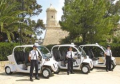
Valletta is served by a fleet of electric taxis which transport riders from 10 points in Valletta to any destination in the city. |
By Car |
Traffic in Malta drives on the left.The main roads of Malta from the southernmost point to the northernmost point are these: Triq Birżebbuġa in Birżebbuġa, Għar Dalam Road and Tal-Barrani Road in Żejtun, Santa Luċija Avenue in Paola, Aldo Moro Street (Trunk Road), 13 December Street and Ħamrun-Marsa Bypass in Marsa, Regional Road in Santa Venera/Msida/Gżira/San Ġwann, St Andrew's Road in Swieqi/Pembroke, Malta, Coast Road in Baħar iċ-Ċagħaq, Salina Road, Kennedy Drive, St. Paul's Bypass and Xemxija Hill in San Pawl il-Baħar, Mistra Hill, Wettinger Street (Mellieħa Bypass) and Marfa Road in Mellieħa. Car ownership in Malta is exceedingly high, given the very small size of the island.Beware that a congestion pricing scheme was implemented to reduce long-term parking and traffic while promoting business in the city. An ANPR-based automated system takes photos of vehicles as they enter and exit the charging zone and vehicle owners are billed according to the duration of their stay. Traffic within the Valletta itself is restricted, with some principal roads being completely pedestrian areas. In 2006, a park and ride system was implemented in order to increase the availability of parking spaces in the city. People can leave their vehicles in a nearby Floriana car park and transfer to a van for the rest of the trip. |
On Foot
|
All chosen hotels in Valletta itself, are within easy walking distance of the conference site. (see hotel page) |

University of Malta - Valletta Campus Location Map